![Item #39426 Journal historique du dernier voyage que feu M. de la Sale fit dans le Golfe de Mexique, pour trouver l'embouchre, & le cours de la Rivière Missicipi nommée à present la riviere de Saint Louis, que traverse la Louisiane… par Monsieur Joutel… redgé & mis en ordr [sic] par Monsieur De Michel. Henri Joutel.](https://rulon.cdn.bibliopolis.com/pictures/39426_1.jpg?width=768&height=1000&fit=bounds&auto=webp&v=1520977992)
![Journal historique du dernier voyage que feu M. de la Sale fit dans le Golfe de Mexique, pour trouver l'embouchre, & le cours de la Rivière Missicipi nommée à present la riviere de Saint Louis, que traverse la Louisiane… par Monsieur Joutel… redgé & mis en ordr [sic] par Monsieur De Michel.](https://rulon.cdn.bibliopolis.com/pictures/39426_2.jpg?auto=webp&v=1520977992)
![Journal historique du dernier voyage que feu M. de la Sale fit dans le Golfe de Mexique, pour trouver l'embouchre, & le cours de la Rivière Missicipi nommée à present la riviere de Saint Louis, que traverse la Louisiane… par Monsieur Joutel… redgé & mis en ordr [sic] par Monsieur De Michel.](https://rulon.cdn.bibliopolis.com/pictures/39426_3.jpg?auto=webp&v=1635196646)
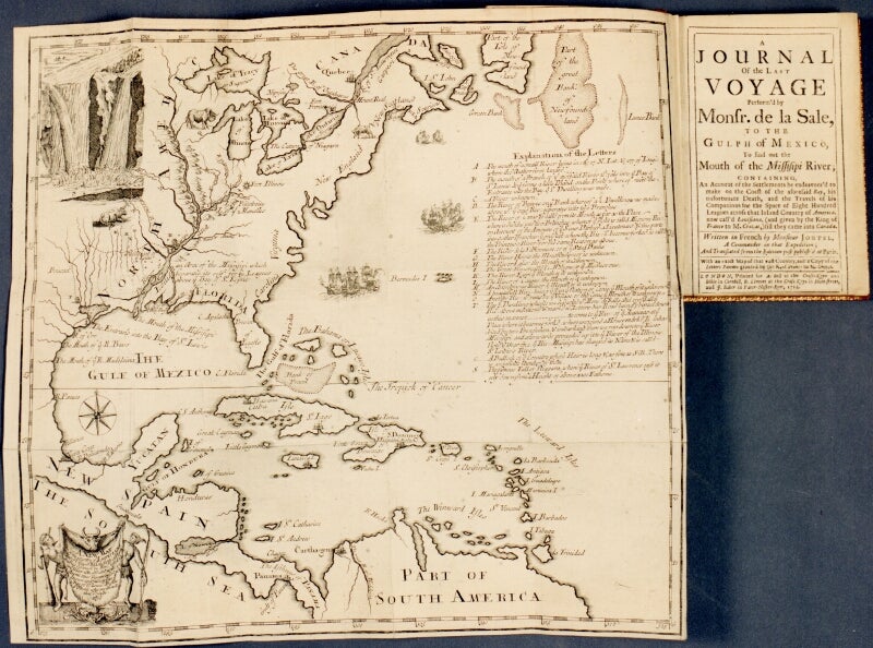
The first accurate delineation of the Mississippi
Journal historique du dernier voyage que feu M. de la Sale fit dans le Golfe de Mexique, pour trouver l'embouchre, & le cours de la Rivière Missicipi nommée à present la riviere de Saint Louis, que traverse la Louisiane… par Monsieur Joutel… redgé & mis en ordr [sic] par Monsieur De Michel.
Paris: chez Estienne Robinot, 1713. First edition, 12mo, pp. xxxiv, 386; engraved folding map (bound in upside down and with a 2-inch tear entering from the stub); full contemporary calf, red morocco label on gilt-decorated spine, sprinkled edges; rubbed and worn, but sound; a good copy; the map is very clean. "Most reliable eye-witness account of La Salle's two-years wanderings in Texas. The map, based on La Salle's Mississippi explorations, was the first accurate delineation of that river" (Howes). Church 855; Howes J-266; Graff 2251; Howes J-266; John Carter Brown I, 177; Sabin 36760. Item #39426
Price: $12,500.00
See all items by Henri Joutel