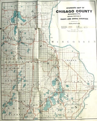
Standard map of Chisago County, Minnesota, showing selected roads in red [cover title]
St. Paul: McGill-Warner Co., 1920. One color map (approx. 648 x 521 mm.) folded down to approx. 178 x 114 mm. in brown printed wrappers; occasional tears from folds, else very good. Map title: "Standard map of Chisago County, Minnesota, showing portions of Isanti and Anoka Counties". University of Minnesota..... More
![Item #34458 官許新刊輿地全圖 [Kankyo shinkan kochi zenshu.] = New version of world map](https://rulon.cdn.bibliopolis.com/pictures/34458_1.jpg?width=320&height=427&fit=bounds&auto=webp&v=1613418213)
![Item #43429 尋常小學地理書附圖 [Jinjō shōgaku chirisho fuzu] =An illustrated atlas for...](https://rulon.cdn.bibliopolis.com/pictures/43429_1.jpg?width=320&height=427&fit=bounds&auto=webp&v=1612994603)