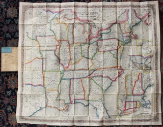
Colton's map of the United States the Canadas &c. showing the rail roads, canals, stage roads, with distances from place to place
New York: J. H. Colton, 1854. Large folding pocket map of the United States and southern Canada east of 99 degrees west longitude, approx. 27" x 31" , nicely hand colored in outline and within an agricultural motif border, with insets of New England, the United States (coast to coast)..... More

![Item #56227 Constitution of the Kingwood [N.J.] Vigilant Society, adopted January 17, 1835 [drop...](https://rulon.cdn.bibliopolis.com/pictures/56227_1.jpg?width=320&height=427&fit=bounds&auto=webp&v=1599086773)